

Customary rights of villages/Tribes/Families/Former Rulers are well understood and practiced effectively even after the discontinuity of hereditary rule in 1974. It is also a fact that misinterpretations have also given rise to unnecessary conflicts within communities resulting in court cases, specially after the discontinuity of hereditary rule. It is a relief to know that these customary practices have been researched through CAK project and now we have a reliable written record of the age old system followed in Hunza. It will help the younger generation to arrive at logical collective decisions when the futuristic civil society entities embark on implementing desirable changes in the distribution of water rights that will be necessitated when either new channels are built or the existing channels are improved or utilization options - for example, HYDRO-POWER schemes are implemented and a review becomes essential. This consideration alone has prompted me to reproduce the same on my blog so that it is available to a wider circle in Hunza.
Please go through this link to read the details of this time tested system. Pages will follow soon.


 vertical
dimension, extreme differences of precipitation conditions have been recorded between arid, desert-like valley bottoms
and the humid nival zone (Hewitt 1989)
thus separating potential settlement regions from those where sufficient humidity is available (Fig. 7.3). Climatic
data are available for longer periods
only from weather stations in the valleys thus showing the limitations for agriculture in the permanent
settlements.
vertical
dimension, extreme differences of precipitation conditions have been recorded between arid, desert-like valley bottoms
and the humid nival zone (Hewitt 1989)
thus separating potential settlement regions from those where sufficient humidity is available (Fig. 7.3). Climatic
data are available for longer periods
only from weather stations in the valleys thus showing the limitations for agriculture in the permanent
settlements. cycles
ranges from 307 days for Gilgit (1450 m
asl), 260 days for Karimabad (2300 m)
to 195 days only for Misgar (3102 m).
cycles
ranges from 307 days for Gilgit (1450 m
asl), 260 days for Karimabad (2300 m)
to 195 days only for Misgar (3102 m).

7
Water Management in Mountain
Oases of the Karakoram
Hermann Kreutzmann
INTRODUCTION
In recent years development
planners have been focussing on the expansion of irrigated lands in order to safeguard the
nutritional basis for a growing population. In the rural areas of the subtropical belts
extending the potential growing period, expanding the area covered by agricultural fields and
improving their productivity on a sustainable basis are components of quite common and widely applied
development strategies. There have been many successes in this approach, especially from marginal
regions where dependence on monsoon rains have been superseded by a steady
supply of irrigation
water from perennial sources. Mountain regions have been quite marginal to such
planning as projects depend on large-scale structures, with major dams creating storage
reservoirs to feed canal networks the size of medium rivers in the plains and piedmont areas.
The water supply for such projects was tapped from the huge glaciated regions up in the mountains,
which have been labelled the water towers of Asia, conducted through major rivers to the densely
populated lowland regions. In Pakistan irrigation projects initiated by public
institutions and development agencies were concentrated in the compact irrigation oases in Punjab and
Sindh, which evolved
into their present status from systems begun in colonial times.
The last two
decades, however, have signalled a basic change in thinking in irrigation design away from the
larger projects, towards the development of more small-scale projects. Since then, mountain regions,
which provide the
meltwater utilized for irrigation in cultivated oases, have become focal points
in water management projects of their own.
Development practitioners have
been surprised by the highly sophisticated state of local water management systems in mountain
societies of the Hindukush-Karakoram-Himalaya
belt.2 Nevertheless, enquiries about
their institutional
framework and social organization and their impact on existing user communities (Coward 1991)
have been neglected and underestimated. This paper presents some of the basic principles of water
management and
explores some of the local variations and diversity of
these principles in a
case study from Hunza.
Like the pre-colonial irrigation
systems of the Indus Basin (cf. Scholz
1985) the mountain irrigation systems are dominated by
gravity flow
techniques to transport irrigation water from a source
(glacier, snowfield, river, fountain) to the cultivated lands through "gravity-fed"
channels. These age-old
systems are remnants of indigenous cultural knowledge and
traditional techniques. As developers are now searching
for models and
appropriate technologies that are both sustainable and
equitable to apply
toward improving these smaller systems, there is a
growing need for
understanding the institutions of these irrigation systems
and how they work.
Hunza presents us with a model
for a water users' community in a region where
there is water scarcity and which has developed a sophisticated system of water management (Fig. 7.1). The
following analysis focuses on this valley
society in the Karakoram. It is felt that a comprehensive knowledge of the functioning of the irrigation network of this
area will provide us with
the key toward understanding its mixed mountain
agriculture and social
structure.
A side effect of the increasing
integration of the high mountain regions into a system of exchange relations with the lowlands and
piedmont has been the
increased provision of agricultural extension services to the mountain oases and that public
(national) and private (international) development agencies have begun to become increasingly
involved in local
irrigation projects. Three aspects will be emphasized on
in the presentation
a multi-dimensional perspective:
1.
regional differentiation of ecological frame conditions and their
relation toward
utilization patterns of natural water resources,
2.
effects of historical and societal processes in the legal and
organizational structure
of water user communities,
3.
recent developments in the irrigation economy linked to external interventions and changing
economic relations.
From a macro-economic perspective
the marginal lands in arid high mountain oases pose a model for the highly sophisticated
utilization of a minimum
of available natural resources. Water poses a key factor in the whole set-up.

ECOLOGICAL AND TECHNOLOGICAL CONDITIONS
OF IRRIGATION IN THE KARAKORAM
The Karakoram mountains (71°-79° E, 35°-36° N)
petrographically and orographically
form one component of the young folded mountain belt of Central Asia (Hewitt
1989; Schneider 1956: 8; Searle 1991). The toponym Karakoram derives from the Turkic expression
for black gravel or black rock. During the colonial discussion of nomenclature (Mason 1930, 1938) the local term Muztagh has been suggested with the meaning of snowy mountains. These two ascriptions present the
ecological range of the Karakoram mountains which on the one hand offer
gravel and deserts on slopes and in the
valley bottoms and on the other hand are characterized in the upper zones by the most extensive ice cover
outside the polar regions.
With an average of 28 per cent
areawise glaciation and regional up to 48 per cent (Siachen glacier region) these snowy mountains
distinguish themselves
in ice coverage significantly from the neighbouring Himalayas (8-12 per cent). The whole range
of 500 kilometres length is only transected by river gorges at two points: the Shyok river in the
East and the Hunza river
in the West cut through the main ridge and the Pleistocene deposits thus creating the canyon-like
valleys with bordering flat river terraces and outwash fans/scree slopes. The
deeply incised main rivers are difficult to tap for irrigation purposes as the elevation between water
level and settlement terraces sometimes spans a vertical distance of over 100
m. Traditionally other solutions for the
provision of irrigation water were found, such as the predominant utilization
of water from tributary rivers. The Hunza valley
has some of the steepest slopes on earth that leaves only limited space for cultivation. Between the Hunza river at
Altit (2100 m) and the Ultar I peak
(7390 m) the average inclination of the slope ranges around 60 per cent.
The valleys represent a typical
subtropical steppic high mountain area with altitudinal zonation of vegetation cover. The
classification of vegetational
belts begins at the valley bottom with desert conditions. Next comes artemisia steppe where most
permanent settlements are located. If one follows the slope gradient upwards, humid-temperated
stretches where coniferous
woods occur locally at northern exposures. Above this is found the zone of high
pastures; an important economic resource is composed of valuable meadows reaching upwards
to the zone of perennial snow and ice (Paffen, Pillewizer and Schneider 1956).
Climatically the Karakoram
mountains form a barrier between the monsoon-dominated lowlands of the Indian subcontinent and
the arid belt of
Central Asia with its huge desert basins of the Tarim and Fergana. The Karakoram valleys are thus
affected by a monsoonal climatic regime as well as by westerly
depressions forming a transition zone (Fig. 7.2). In the

The total annual precipitation in
these valleys is only about 130 mm on average and is well below minimal requirements for
rain-fed (barani cultivation. On the other hand, measurements of ablation
and calculations suggest
maximum precipitation at 5000 metres altitude of approximately 2000 mm. This significant gradient
explains the desert conditions in the villages and the enormous glaciation in the upper
elevations.3
Mean average temperatures
seasonally vary with maxima in July/August and minima in January with an amplitude of 25° C (cf. Fig.
7.2). In glaciated region like the
Karakoram these variations in temperature determine and actuate the volume of available meltwater
for irrigation the
valley bottoms. The seasonal differences are reflected in the discharg patterns of the rivers (Fig. 7.4). The period of seasonal meltwater
relea relates to the
climatic conditions and determines in connection with th altitudinal location of settlements
the length of the cultivation period f crops in these irrigation oases. The average duration of
annual growing.

Relief, availability of meltwater and vegetation period in
different locations (altitude, aspect) form the parameters for the possibility
of establishing
sustainable irrigation oases in the Karakoram. The storage capacity of the mighty ice towers
is tapped and meltwater are deviated towards irrigated fields in locations which compose
ecological and agro-technological
niches with favourable conditions for crop farming. Thus the irrigated oases of the Karakoram
are located on river terraces and outwash fans in the arid low-lying valley bottoms. They allow a
maximum utilization of
the limited vegetation period where the provision of sufficient meltwater from
side-valleys is safeguarded through a highly sophisticated network of irrigation
channels. Overall these cultivated areas cover less than one percent of the Karakoram mountains.
IRRIGATION AND LAND USE: OASIS
AGRICULTURE AND ORGANIZATIONAL
STRUCTURES
The rural societies of the Karakoram differentiate
themselves in many ways
despite a
principally similar ecological environment and a relatively homogeneous materialized culture.
One of the main characteristics of individual valleys poses the traditional social
organization. Staley (1969) has distinguished two basic types:
1. Semi-autonomous and
independent principalities represent the dominant feature of hereditary rule in the northern
Karakoram valleys. Local mir, raja or tham dominated peasant farmers
of different social standing places like
Gupis, Yasin, Ishkoman, Punial, Gilgit, Hunza, Nager, Astore, Skardu and Khaplu. These rulers over a peasant
community executed certain control,
levied taxes and requested forced labour services from the rural households.
2. Following the Yusufzai Pashtun conquest of Swat and
Indus Kohistan since the fourteenth century
so-called acephalous societies or republics have emerged in the mountainous interface of the southern valleys like Chilas, Tangir, Darel, Gor, Kandia etc. They have
established egalitarian community to
which all landowners belong. They are entitled
to participate in the decision-making
process of all village activities like distribution of land, construction and
maintenance of irrigation chanels etc.
No hereditary ruler is present; every member possesses equal rights. The
forum for counselling is the jirga, a local assembly basing its decisions
on overall consent. Besides the landed members of society


Source: AKRSP 1989: 52; AKRSP 1992: 24-28; IOL/P&S/7/165/1094; IOL/P&S/7/171/2013A, 2142A: IOL/P&S/7/172/2263A; IOL/P&S/7/173/283, 351; IOL/P&S/7/174/428; IOL/P&S/7/178/1038; IOL/P&Sl 10/826: 16, 18, 60, 66, 240; IOL/P&S/10/973: 161, 226, 243; IOL/P&S/12/3285; IOR/ 2/1075/217: 50 54; IOR/2/1083/ 286: 11; Lorimer 1935-8,11: 353; MUller-Stellrecht 1978: 114; Nazim Khan 1936: 120; PRO/ F065/1507: 29; Singh 1917: 27 and own data collected by observations and interviews 1984-9


Staley (1966)
observed distinguishing features between these two societal settings. The cultural landscape
of the republics was devoid of any orchards, a trait that has been related to the land
rotation system of wesh ' Agricultural tasks are predominantly executed by
indebted wage-labourers from outside, who are tolerated as employees. Intensity of crop farming
has been low and cultivable
land abounds. In comparison with the principalities, the agricultural resources of the
republics are abundant and underutilized. There landowners work their small holdings (on average
less than one hectare per household) themselves and are engaged in intensive exploitation of
available resources.
The upper limits of certain crops are significantly higher in the principalities than in the
republics. Natural forests have been depleted to a high degree. Scarce water
resources are optimized in a highly sophisticated system of water management by
ascribing qualified priorities to different crops,
orchards and meadows.
In this respect an
extraordinary position is held by Hunza which has gained a reputation for the
development of marginal resources. Hunza professionals managed to cultivate difficult tracts,
their expertise in designing
and construction of irrigation networks won them assignments in other Karakoram valleys. In its
complexity, the Hunza water management system
incorporates a number of rules and, regulations that are applied in different configurations in other Karakoram
valleys as well. Where water scarcity is the dominating feature like in the
irrigation system of Central Hunza
the complexity of water management increases.
WATER MANAGEMENT IN CENTRAL HUNZA
The vast majority of all
irrigation systems in Hindukush, Karakoram and Himalaya use gravity-fed
networks to conduct running meltwater through channels which are directed less steeply than the
slope gradient and in some cases nearly parallel to contour lines. The same applies for Hunza where
the village lands
receive their "glacier milk" from channels that supply enormous amounts of suspended matter at the same time.
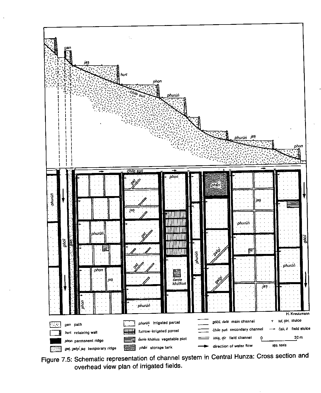
This characteristic surface irrigation
system consists of main channels (dalk, khul or gocil) which start at the head-works with a diversion of
water into filter basins. These are necessary to settle huge amounts of.
suspended silt and sand from the
meltwater before sending it down the network. Despite these efforts, much sediment still has to be
cleared annually from the main channels
before the irrigation season starts. The irrigation water is distributed to the fields through a system of secondary
channels (sun) which follow the

Individual fields receive their
allocated share of water through field channels (dir,
irkis) which
reach all parcels through the opening and closing of individual field sluices (cak, il). Two different types of
cultivation beds (phurun) are used in Hunza: flat parcels
for the raising of grain crops and leguminous plants in which some small patches for
vegetables (sanie khutkus) are inserted, and furrow beds for root crops
predominantly potatoes. The flat parcels
account for 97 per cent of the cropland (harkis; Fig. 7.6) and receive irrigation water through flooding. The furrow
beds are allocated water
by opening and connecting these furrows during a single cycle. The cultivation beds meant for the
raising of the staple food crops (harkis) of the village lands
(icit) commands first priority of water rights and is given preference against orchards (basikis) and irrigated meadows (toq). The latter are
only irrigated during periods of surplus water. These irrigation techniques and priority measures are structuring the village
lands.
In regions with a limited supply and intensive cultivation
further measures are taken to optimize the
use of the available water by levelling the terraces and applying a complex
distribution key. Where water is less a factor in the farming system, its management requires less
effort and less emphasis is placed on
setting up rules and controlling consensually fixed regulations.
Evolution of
Channel Network and Adaptation of Irrigation Rules in Central
Hunza
The historical dimension in an
expanding irrigation system in Central Hunza can be linked to initiatives of different rulers.
The core of this system was formed by an old structure of the three oldest settlements, which were supplied with water from
individual channels leading to their respective village lands. The Hamaci
channel forms the lifeline of Ganesh, and Altit gocil brings meltwater to the
village of the same name. Both channels tap the Ultar glacier as their main resource. The Balti-il
links the fortified village of Baltic
(renamed Karimabad since 1983) with the waters of the Bululo snowfields and springs. This poor resource basin is drained by the
Haiderabad Har which provides the Balti-il its offtake. The age of these
three oldest channels of Central Hunza has
not been established, but they could
be well over 600 years old.5
No important extensions
to the system were contemplated until Tham Silum Khan III (app. 1790-1825) founded several new
villages (thuaan khananc). His reign can be characterized as
a period of population growth, immigration of settlers, territorial gains and strengthening of
centralized authority
in Hunza. In order to establish settlement nuclei in the newly cultivated irrigation oases, he
directed the construction of the thuaan
khananc as
fortified villages. The name of Silum Khan III is associated with the main channel of Central Hunza. The
dala (big channel) or Khul Samarkand, as it is locally called,
still irrigates the lower portion of the central irrigation oasis between Karimabad and
Aliabad (Tab. 7.1).


Source: AKRSP 1989: 52; AKRSP 1992: 24-28; IOL/P&S/7/165/1094; IOL/P&S/7/171/2013A, 2142A: IOL/P&S/7/172/2263A; IOL/P&S/7/173/283, 351; IOL/P&S/7/174/428; IOL/P&S/7/178/1038; IOL/P&Sl 10/826: 16, 18, 60, 66, 240; IOL/P&S/10/973: 161, 226, 243; IOL/P&S/12/3285; IOR/ 2/1075/217: 50 54; IOR/2/1083/ 286: 11; Lorimer 1935-8,11: 353; MUller-Stellrecht 1978: 114; Nazim Khan 1936: 120; PRO/ F065/1507: 29; Singh 1917: 27 and own data collected by observations and interviews 1984-9
All settlers of Baltit
participated in the construction of the new channel and through this the people of
the thuaan khananc, originating mainly from Baltit (the filial settlements of Haiderabad and
Aliabad are composed of the same kinship groups as Baltit), were connected to the dala. This
new channel afforded a revised distribution
key for the Ultar meltwater, dividing half of the
available water into the dala network (two shares), while one share each was allocated for Altit gocil and Hamaci. This
distributive formula is still being
followed and gives priority to these oldest channels in periods of water scarcity (autumn to spring).
During summer, when surplus irrigation water above the
carrying capacity of the old channels is
available, newer channels are eligible for water share This newer group is composed of channels
constructed under the guidance of Silum
Khan's successors. His son and grandson found in wazir Asadullah Beg
(1847-85) an able local engineer for further-irrigation projects. Members of his own clan respect his name especially as he
enabled the Diramiting tap the Diracil
spring and command its waters. In addition to this achievement, he supervised the construction of the second major channel Central Hunza bringing water to the upper fields.
The Barber following the course of the dala on a higher contour line supplied the water for newly meliorised fields above the
traditional village lands.
On the one hand new channels
provided arable land for a growing population, on the other channel projects executed under
forced labour conditions
(rajaaki) increased the land resources and income of the hereditary ruler and the wazir households. These main channels of Central Hunza were established around 1850 and compose the
skeleton of present-day network. A
number of smaller and secondary channels complete this system. Water to be distributed in these later built channels can
only be supplied during periods of
surplus and they therefore serve only a marginal role compared to the main channels in Central Hunza.
During the twentieth
century the enterprising ruler Mir M. Nazim Kh (1892-1938) initiated another phase of channel
construction (Tab. 7.1). thus irrigation policy was characterized
by the establishment of new village oases outside
Central Hunza in the single-cropping zone of Ghujal and down Hunza River in the double-cropping zone of Shinaki
(cf. Fig. 7.1) thus tapping
unexploited or underutilized sources of meltwater. These young villages
command, on average, a good supply of water and require fewer rules and
regulations than the core oases. In this area, even with its simple regulations,
the expansion of the irrigation network and the construction of new channels have contributed to
the overall complex codex of water rights for Hunza. In these new areas
different rights of water allocation have been laid down for certain channels both for periods
of water shortage and surplus. On the other hand the irrigated lands are classified in three groups:
·
First priority of
irrigation belongs to cropland (harkis) which requires regular
watering during the different growth stages and on which the staple cereals are produced,
·
Second priority goes to the orchards (basikis) providing an additional nutritional base to the villagers
from fruit trees which require less intensive and less frequent water supply,
·
Third priority goes to irrigated meadows (toq) on steep slopes within the village lands which are entitled
to excessive water supply only during non-growth stages in the other parcels.
This allocation pattern for village lands reflects an
irrigation order with preferential
treatment of differentiated production zones more than the agroecological setting. In channels
with "old" water rights, like Balti-il and Barber, one would predominantly
find orchards as only surplus water is available for irrigation, not sufficient for cereal
production in quantity and variability. During the short period after harvest and before sowing the winter crops no irrigation water is needed for
agricultural lands and orchards. Thus the
irrigated meadows (toq) are
qualified for the full load of available irrigation water (Fig. 7.7).
IRRIGATION CALENDAR FOR CENTRAL HUNZA
Seasonality
plays a major role in the flexible approach to organizing water management in Hunza. The quantity of meltwater
released from Ultar glacier depends on temperature
variations which is reflected in the discharge patterns of the tributaries of the Hunza river (cf. Fig. 7.4).
The irrigation calendar for Central Hunza takes into account that periods
of surplus alter with periods of
grave deficiency. The basic water supply is precisely distributed during
all seasons according to a legal set which is binding to all participants. This codex is common knowledge and not written
down or fixed like in other mountain
regions. The contemporary set of rules and regulations is the result of historically acquired water rights of
user groups and modifications
directed by the hereditary rulers.
The participation of clans and village communities
in the construction of new irrigation channels secured their
rights to water and lands. Individual channels belong to certain groups of this denomination
exclusively. A second

criterion for water distribution
is the traditional right of access to irrigation water belonging to certain clans or
kinship groups. In cases of kinship and spatial congruency, i.e., when the parcelling of village lands follows a
group structure, water distribution is
highly efficient as certain areas are irrigated at the same time. Seepage and water losses in a dendritic irrigation
network are thus minimized.
Baltit or Karimabad
poses an ideally structured example for this kind of setup. Sectors of the village lands are
distinguished as belonging to certain kinship groups. The quarters of the four clans of
the Diramitin, Buroon, Baratalin and Qhurukuc define the agricultural oasis only modified by the
possessions of the hereditary ruler. The miri lands were traditionally located
in every favourable cultivation area, like in Bul Mal, Karimabad (Suryas Das),
and Bishker. In recent years the majority of the miri lands have been sold to individual
villagers of Karimabad thus we find there a mixed kinship-related ownership.
A synoptic table of
water rights, irrigation cycles and rules of distribution for the main channels of Central Hunza
presents the historic evolution and complexity of water management (Tab. 7.2). First priority of access rests
with the oldest channels and rights acquired through kinship participation in the construction of
channels. Measurements
of water flow in different seasons (Fig. 7.7) proved the applicability of distribution keys. The share
structure-Dala: Altit gocil: Hamaci = 2:1:1-is controlled at certain gates where the water flow
is diverted into the different systems. In
periods of deficiency extra guards control the exact adherence to these
distribution keys while during surplus
phases control is relaxed.
A second method of
rationing is the hourly or daily right of water utilization. For example, the Bululo water is split
in a rhythm which allows the inhabitants of Karimabad (Baltit) to use it for ten days, while the
Haiderabad people's share is only six days. The water in the Barber channel belongs to the community
of Karimabad during
the day, while at nighttime the users at the lower end of the Barber
(Haiderabad-Dorkhan-Aliabad) safeguard all water for the irrigation of their
respective fields. Priority rights of the tham included a sufficient share of
water and the irrigation
of his fields only in favourable daylight conditions. Even after the abolition of hereditary rule in
1974 the traditional miri water rights remained valid through the connection of water
and land rights.

The user communities distribute
the allocated water among themselves according
to allocation keys which are laid down by their members. A complex system is applied in Haiderabad. Six days
of Bululo water have to be divided
among four kinship groups (the same like in Baltit). The Haiderabad people have formed six user groups of
equal size. Four groups consisting of
Diramiting, Buroon, Baratalin and Qhurukuc, respectively, and two groups of Baskaotin (from bask, literally meaning surplus, in addition). The members of the Baskaotin are the extra
households of the four clans that are
numerically in excess of the group size.
On the other hand, in Karimabad
the ten-day-cycle is distributed among the four room in a manner that schedules irrigation for two days and three
nights or three days
and two nights are allocated to the relevant kinship groups. Every year a different
clan begins the irrigation cycle thus avoiding any preferential arrangement for individual
kinship groups. Within these user communities the irrigation sequence varies annually from top to
bottom and from East
to West (cf. Tab. 7.2). These examples illustrate the wide range of possible communal agreements that have
been established in order to safeguard
equity for all users.
These cycles of six or ten days
respectively present no real indicator for the actual time required to irrigate all the fields of a
user group. In periods of water deficiency, e.g. during the sowing of winter wheat (Triticum aestivum) in November/December or of summer barley (Hordeum
vulgare) in February/March, the
total time necessary to irrigate all fields once could amount to forty-eight days. In order to maximize
the use of available water the whole
community has adapted a cultivation pattern in which the first crops of winter wheat and summer barley are
represented in equal quantities (cf.
Fig. 7.6). Both are sown in deficiency
periods. On the contrary the second
crops like maize (Zea mays), millets (Panicum
miliaceum; Setaria italica), potatoes (Solanum tuberosum) and buckwheat (Fagopyrum esculentum and tataricum) are exempted from such regulations. In summer, surplus conditions of no water shortage prevail
and the entire village land of Central
Hunza can be irrigated within a sixteen-day cycle.
Valuable water resources have to
be distributed according to systematic management and plant requirements. Top
priority is given to cereal crops on irrigated terraces (harkis). After the first watering (buruui) of
all wheat fields, barley is irrigated. Then follow potato furrows, vegetable
plots ('san
khutkus) and at last lucerne (Medicago sativa). This regulated
sequence repeated at
the second watering (yktcil) and is only relaxed when sufficie water is available in the old
channels. With the end of restrictive water us the first irrigation of orchards (basikis) is
permitted. The timing of this da in relation to the summer solstice (21 June) gives the
measurement for the classification of a good or bad
"water year".
This complex system of rationing is applied in Central
Hunza in those settlements
that command limited water sources or have grown beyond their resource capacity.
Communities with abundant irrigation water do not need such a highly
sophisticated distribution key to safeguard a high probability of sufficient crop production. Villages like Altit,
for example, allot the annual
sequence of irrigation every year through the drawing of lots, while in Ganesh
the rotational structure is fixed.
Different kinship groups are in
command of day or night cycles. Some water rights incorporate structural inadequacy of the
systems, such as in the case of the Barber channel, where parties whose parcels are located
nearer to the source
are given preference. Karimabad as a whole is allowed Barber water during daylight hours,
while Haiderabad, Dorkhan and Aliabad utilize the precious resource at night. The farmers of the
Diramitin kinship group in Karimabad profit from the location of their agricultural lands in the
same manner as the
people of Haiderabad and can divert any needed quantity of water to their fields. The
difficult location of Aliabad at the lower end of Barber, Dala and Pir gocil results
in greater water deficiency in this village than
in others. Topographical features in combination with settlement history pinpoint the structural injustice. An additional
factor contributes to the water supply situation, for along the course of the
10 kilometre-long open channels a
substantial quantity of water is lost by evaporation and seepage.
Water channels function as
multipurpose lines. Besides irrigation, the system provides all washing and drinking water as well.
Unfortunately, such channels furnish poor quality drinking water badly affected
by contamination.
Thus without control of its own water sources, the second biggest village of
Hunza, Aliabad, is the most dependent on other areas for drinking and irrigation water
supply. The village community is eager to reduce further losses and irrigates all fields
consecutively: one year the irrigation starts in the east, the following year in the west.
Ecological limitations are
responsible for these rules and regulations to a lesser degree than socio-political and historical
events. They laid the foundations
for water rights of certain user groups which have to be defended against competitors. Water surplus
and deficiency regions are defined by traditional rights of individual groups.
Complex irrigation systems afford community efforts during construction and regular
maintenance in which all social groups (household, kinship group, and village) are involved on different levels of
participation.
ORGANIZATIONAL
ASPECTS OF WATER MANAGEMENT
The tham of Hunza has traditionally taken
the initiative for the planning and execution of construction work on
irrigation channels. He normally involved his wazir in this enterprise
of state importance in his dual function as prime minister and executive
engineer for planning and supervision. The respective kinship groups or village communities served as construction workers.
Early major channel projects
accomplished general construction with simple technical devices and tools like wooden shovels and ibex horns (cf. the contribution of Hussain Wali Khan and Izhar Ali
Hunzai in this volume). Sheer cliffs
were mastered with support structures made of wood and stone. The reputation of
wazir
and workers increased through
ingenious channel alignments and they
secured usufructory rights to the meliorated lands through their participation in rajaaki.
Communal work of comparative size
is only called for in certain cases nowadays, for example when a new storage tank (phari) has
to be excavated or
when a channel has been breached. In the latter case, all user households have to co-operate until the
breached channel has been repaired or until new course has been excavated.
Except for these exceptional or episodic events, fewer individuals are required in the management of
channel systems through
the regular activities of operation and maintenance.
The annual cleaning and repair
work starts prior to the first irrigation of crops in spring. Farmers who own land within the
channel command area are
obligated to remove the deposited sediment of the previous year from the channel-bed. These activities
were traditionally controlled by the wazir, who supervised the works and
possessed the right to sanction those who do not participate according to the rules (cf. Lorimer
1979: 126-133). His influence
in allocating the various jobs in water management contributed to his esteem as the chief hydraulic
supervisor.
When Hunza lost its autonomy in
1974, the wazir's post was abolished along with the post of the tham. The traditional functions of the wazir are nowadays executed either by the lambardar or
by village committees. Every year the group of village elders assembles in a jirga that distributes the remunerated water management posts
among community members for the coming irrigation period. The jirga nominates a supervisor and the
water workers (chilgalas) who
safeguard the correct distribution schedule and the allocation of water to individual
land parcels. They are responsible for checking water theft and have to announce the timing of
irrigation to individual
households. Minor maintenance work is done by the chilgalas as well. Non-participating
households pay a fixed amount in kind or money that basically pays the salary of the water workers.
The number of chilgalas and
the water rates are negotiated anew each year and depend on the size of the available village work
force. Traditionally these
salaried duties formed a highly esteemed way of providing an income to those households with
insufficient lands to profitably employ their surplus male work force. Given changes in socio-economic
conditions with increased labour emigration
and more farmers involved in non-agrarian occupations, such traditional jobs in water management have
lost their attraction. This has
resulted in increased salaries for these irrigation workers in order to secure local personnel and to safeguard the system
of water distribution. Though the cash
investment in hiring such people remains within the community, the difficulty in obtaining reliable
and expert people for these tasks
causes a growing problem for some villages.
Nowadays, often even elderly and
retired men are appointed as water guards (yatkuin) to supervise the proportional and
equitable distribution of irrigation water at the channel heads. These functionaries are elected
for one year and
safeguard the fair allocation of water to different communities. The yatkuin are responsible for all duties at
the channel heads including the cleaning of sedimentation tanks in which suspended sand
particles are precipitated.
During periods of surplus water, the yatkuin limit the flow capacity of
individual channel systems to avoid breaching of channels.. The yatkuin reside in simple huts or caves in
the Ultar nala and in the vicinity of important channel bifurcations during the entire
irrigation period. After the end of harvest in autumn they are remunerated in kind, collecting 1-2 kilograms of wheat per channel
from every household.
In times of water shortage
additional supervisors are brought in to
support the appointed guards. Settlements
like Haiderabad cannot afford water loss during the early stages of plant growth when overall water shortage in central Hunza increases the chances for water theft
by individual farmers. Thus during
nighttime, villagers control all ten outlets along the way from Karimabad to Haiderabad in order to protect all tul and
tori from being opened unlawfully. In spite of these measures, water theft along with inheritance quarrels still account for the
majority of disputes in Hunza each year.
Traditionally the tham fined
those found to be stealing water in kind, taking a good share of the penalty for himself. Nowadays
the local Ismaili Arbitration
and Reconciliation Boards are involved in the legal proceedings. They operate cost-free and
compensate the winning party with the entire fine. Some cases are even presented before the
public courts (see the contribution by Anna Schmid elsewhere in this volume).
The analysis of the irrigation
system in central Hunza has revealed the spectrum of different water rights and
organizational rules. based on traditional
access to resources and an effective utilization of a limited resource. Fair distribution among entitled
community members forms the principle
in an approach which rejects the separation of water and land rights. Supervision and control of the irrigation
networks that nowadays have become
community members' own property is executed by themselves on the basis of consent. Scarcity and complicated
distribution keys have increased the
bureaucratic burden of water management. In periods of deficiency small but highly valued quantities of
water have to be guarded on their way
to the fields. This practice requires substantial manpower, as sluices are numerous. At the same time the system
always favours the users residing
close to the water source. Generally, they are the oldest settlers of the oases.
Future projects for the
construction of new channels have to respect the traditional water rights. This
precondition involves certain limitations: Excess meltwater can only be utilized during summer
surplus periods. In all other seasons there is no additional water supply available to be
tapped. New channels
cannot reduce the ubiquitous seasonal water deficiency. Thus the scope for the extension of
irrigated areas lies mainly in the reduction of seepage and evaporation in
existing networks.
RECENT DEVELOPMENTS IN THE
IRRIGATED OASES OF HUNZA
As explained above, new channel
projects increased Hunza's power and economic base during the reign of
hereditary rulers and their wazir. The range of such enterprises was not
limited to the main settlement oasis of Central Hunza (cf. Tab. 7.1). Territorial claims and gains
were manifested through the establishment of new villages in the
southern and northern periphery. Such
projects could involve groups of 20 to 100 household members, which were supported by their families in
the early phase of meliorisation.
Resettled farmers from Baltit and Haiderabad and refugees/ migrants from Wakhan
supported expansive plans of the tham in
the upper Hunza valley (Ghujal) and
founded several villages there (Fig. 7.1). This single-cropping zone
abounds with water sources when compared to the other regions.
In the lower Hunza valley
(Shinaki) a limited quantity of meltwater from the Maiun nala was utilized to establish a number
of fortified villages in the double-cropping area. The main period of internal
colonization is connected with the name of Mir M. Nazim Khan (1892-1938) who established a number of villages for a growing
population. His successors initiated only a few additional channel projects (Tab. 7.1). The end of
hereditary rule in the Northern Areas
by 1974 left a power vacuum which was supposed to be filled by institutions from the Pakistan
administration. Their involvement in infrastructure
projects dramatically increased after the completion of the Karakoram Highway (Kreutzmann 1991, 1993, 1995a,
b). Within the Northern Areas a few
attempts to establish new irrigation projects were undertaken while in Hunza itself, village
communities executed their own channel
building using traditional techniques. Village elders were entrusted to supervise the planning and construction of a
number of minor projects.
Different development agencies
discovered this structural power vacuum and based their target-oriented approaches on
self-reliance strategies. Village Production Groups (VPG) and Village Organisations (VO)
took over the role of
decision-making once held by more traditional institutions such as the tham and wazir. These
institutions now identified necessary physical infrastructure projects and managed the workload seeking financial and technological support from external development
aid. These agencies have supplied
cost-free technical advice to the villages through local engineers in their employ. Other major differences from the
past have been that:
·
The construction cost is now covered from outside sources; man-days are paid for and not supplied through
forced labour (rajakki);
·
The channels belong to the community working on them; all participants are entitled to an equal share of
water in the irrigated lands. No extra plots are reserved for the tham and wazir or any other high status individuals anymore;
· Water management and maintenance
of channels is delegated to
·
professionals (chowkidar) who earn more than any traditional
supervisor;
·
Development agencies supply modern technical equipment for drilling
·
and blasting at nominal costs.
Under these favourable conditions
a number of irrigation projects have been executed in Hunza identified by the
villagers as having top priority. Within the last decade forty-eight physical infrastructure
projects have been initiated
which aim at the expansion and widening of existing gdcil as well as the construction of new channels (Fig. 7.8). In
addition, a few experiments have been
executed with siphon (Nasirabad), pipe (Kamaris) and sprinkler (Galapan) irrigation. Several storage reservoirs and sedimentation tanks have been constructed as well in the productive
physical infrastructure section of the
Aga Khan Rural Support Programme (AKRSP). Among these projects has been the prestigious effort to free
the water supply of central Hunza from total reliance on the Hassanabad
glacier. The first phase of the so-called Aliabad gocil was accomplished by
1988 and it is expected that eventually
700 hectares of land will be watered from this new source (Khan 1994) and the irrigation schedule of central Hunza
(Tab. 7.2) might be altered to
reflect this change of supply.
This difficult project cost the
loss of local farmers' lives during construction in which all concerned villages between
Karimabad to Aliabad participated.
If this channel will ever become sustainable-an assertion which has not yet been proven-the
water deficient villages of Aliabad and Haiderabad will be in a position to irrigate all
available land with sufficient quantities of water. The agricultural landscape of those villages would
be effected in such a manner that present-day priority rules for crops could be
totally relaxed and
even marginal plots could be productively utilized. A similar judgment would apply for
the remaining villages of central Hunza which would be left with a greater quantity of irrigation
water from traditional
sources.
So far, however, the new channel can only be deemed a
partial success since
water flow could not be sustained. Another danger lies in the channel head near the mouth of the
Hassanabad glacier. Should the 16 kilometre-long glacier advance only a few hundred metres, it would destroy the
channel intake which presently lies only 40
m below in vertical distance. The Aliabad gocil is a great example of a project that could not have been feasible
for a village community depending on
its own resources. International development
aid provides a means of experimenting with new techniques and formerly unprofitable projects. If sustainable
development can be envisaged, these
projects will increase the agricultural resource base of this mountain valley.
In case of failure, only the remuneration of the work force and the communal
organizations, which have been developed, will survive. Those ruins of irrigation channels would not be the
first and shall not be the last
remnants of attempts to maximize the utilization of meagre natural resources in the Karakoram.
BIBLIOGRAPHY
Aga Khan
Rural Support Programme. (1989). Sixth Annual Review 1988. Gilgit.
(1990). Productive
Physical Infrastructure (PPI) as of Sept. 30, 1990. Gilgit.
(1992). Ninth Annual Review 1991. Gilgit.
Barth, F. (1956). Indus and
Swat Kohistan-an ethnographic survey. In: Studies
honouring
the Centennial of Universitetets Etnografiske
Museum, Oslo 1857-1957; Vol. II. Oslo: 5
98.
Braun, G.
(1996). Vegetationsgeographische Untersuchungen im
NW-Karakorum (Pakistan).
Bonn (=
Bonner Geographische Abhandlungen 93).
Charles,
C. (1985). La Vallee de Hunza, Karakorum-Pakistan-Milieu
Naturel, Amenagement traditionel et
mutations recentes dans une vallee aride du Nord-Ouest de L'Ensemble Himalayen. Grenoble.
Coward,
E. W. (1991). Planning Technical and Social Change in Irrigated Areas. In:
Cernea, M. M. (ed.): Putting People First. Sociological
Variables in Rural Development. New York: 46-72.
Ehlers, E.
(1985). The Iranian Village: A socio-economic microcosm. In: Beaumont, P. and
K.
McLachlan (eds.): Agricultural
development in the Middle East. Chichester: 151-170. Fautz, B. (1963). Sozialstruktur and Bodennutzung in der
Kulturlandschaft des Swat (Nord
westhimalaya). GieBen (= GieBener Geographische Schriften 3).
Ferguson,
R. I. (1984). Sediment Load of the Hunza River. In: Miller, K. J. (ed.): The
International Karakoram Project, Vol. II. Cambridge: 581-598.
Flohn,
H. (1958). Beitrage zur Klimakunde von Hochasien. In: Erdkunde 12: 294-308. Grbtzbach, E. (1973). Formen
bauerlicher Wirtschaft an der Obergrenze der Dauersiedlung
im
afghanischen Hindukusch. In: Erdwissenschaftliche Forschungen 5: 52-61.
Haserodt,
K. (1984). AbfluBverhalten der Fitisse mit Bezugen zur Sonnenscheindauer and
zum
Niederschlag zwischen Hindukusch (Chitral) and Hunza-Karakorum (Gilgit,
Nordpakistan).
In: Mitteilungen
der Geographischen Gesellschaft in Miinchen 69: 129
161.
Hewitt, K.
(1989). The altitudinal organisation of Karakoram geomorphic processes and
depositional
environments. In: Zeitschrift fiir Geomorphologie N.F. 76: 9-32.
Hughes, R.
(1985). Baltit Fort-Conservation. London.
Hughes, R.
and D. Lefort. (1986). At the Roof of the World. The Baltit Fort. In: Mimar
20: 10-19.
Hunt, R.
and E. Hunt. (1976). Canal Irrigation and Social Organization. In: Current
Anthropology 17
(3): 389-411.
India
Office Library and Records. Files relating to Indian States extracted from the
Political and Secret Letters from India 1881-1911: IOL/P&S/7/165/1094;
IOL/P&S/7/171/2013A, 2142A;
IOLIP&S/7/172/2263A; IOL/P&S/7/173/283, 351; IOL/P&S/7/174/428;
IOL/P&S/ 7/178/1038.
____ . Departmental
Papers: Political and Secret Seperate (or Subject) Files 1902-1931:
IOL/P&S/10/826:
16, 18, 60, 66, 240; IOL/P&S/10/973: 161, 226, 243.
____ . Departmental
Papers: Political and Secret Internal Files and Collections 1931
1947: IOL/P&S/12/3285
____ . Crown
Representative's Records-Miscellaneous Files (Confidential): IOR/2/1075/ 217: 50-54.
____ . Crown
Representative's Records-Indian States Residencies-Gilgit, Chilas, Hunza and
Nagir Files (Confidential): IOR/2/1083/286:
11.
Janjua, Z. J. (1996).
Tradition and Change in Darel and Tangir Valleys. Peshawar (manuscript 14 pp., extract from his dissertational work; to be
published in the Proceedings of the CAK
Conference, Islamabad 1995).
Jettmar,
K. (1961). Ethnological research in Dardistan 1958. In: Proceedings
American Philosophical Society 105 (1): 79-97.
____ . (1977).
Bolor-a contribution to the political and ethnic geography of North
Pakistan.
In: Zentralasiatische
Studien 11: 411-448.
____ . (1982).
Indus Kohistan. An Ethnographic and Linguistic Overview. In: Kohistan
Development Board News 2: 6-13.
Khan, H.
W. (1994). Aliabad Irrigation Channel, Hunza, Pakistan. In: Yoder, R. (ed.): Designing Irrigation Structures for
Mountainous Environments. A Handbook of Experience. Colombo: 93-97.
Kreutzmann,
H. (1988). Oases of the Karakorum: Evolution of Irrigation and Social Organization in Hunza, North
Pakistan. In: Allan, N. J. R., Knapp, G. W. and C. Stadel (eds.). Human Impact
on Mountains. Totowa
N. J.: 243-254.
(1989). Hunza-Landliche Entwicklung im Karakorum. Berlin (= Abhandlungen Anthropogeographie Bd. 44).
(1990).
Oasenbewasserung im Karakorum. Autochthone Techniken and exogene Uberpragung in der Hochgebirgslandwirtschaft
Nordpakistans. In: Erdkunde 44: 10-23.
(1991).
The Karakoram Highway: The Impact of Road Construction on Mountain Societies. In: Modern Asian
Studies 25 (4): 711-736.
__________ . (1993).
Challenge and Response in the Karakoram. Socio-economic transformation in
Hunza, Northern Areas, Pakistan. In: Mountain
Research and Development 13 (1): 1939.
__________ . (1994).
Habitat conditions and settlement processes in the Hindukush-Karakoram. In: Petermanns Geographische Mitteilungen 138 (6): 337-356.
(1995a).
Globalization, spatial integration and their impact on sustainable development in Northern Pakistan.
In: Mountain
Research and Development 15 (3): 213227.
__________ . (1995b).
Communication and cash crop production in the Karakoram: Exchange Relations under Transformation. In: Culture
Area Karakorum Research Project. Occasional Papers 2: 100-117.
Lorimer, D. L. R. (1935-1938). The Burushaski
Language. Oslo (= Instituttet
for Sammenlignende
Kulturforskning, Serie B: Skrifter XXIX-1-3).
__________ . (1979-1980).
Materialien
zur Ethnographie Dardistans (Pakistan). Aus den nachgelassenen
Aufzeichnungen von D. L. R. Lorimer (edited
and commented on by I. Mtiller-Stellrecht). Part 1: Hunza. Graz 1979. Part 2/3:
Gilgit. Chitral and Yasin. Graz 1980
(= Bergvolker im Hindukusch and Karakorum 3).
Manzar Zarin, M. and R. L. Schmidt. (1984). Discussions with Hariq. Land Tenure and Transhumance in Indus Kohistan. Islamabad and Berkeley.
Mason, K. (1930). The Proposed Nomenclature of the
Karakoram Himalaya. In: The Geographical
Journal 75: 38-44.
(1938).
Karakoram Nomenclature. In: The Geographical Journal 91: 123-152.
Miehe, G. (1996). On the connexion of vegetation dynamics
with climatic changes in High Asia. In: Paleogeography, Paleoclimatology, Paleoecology 120: 5-24.
Miehe,
S. et al. (1996). Humidity conditions in the Western Karakorum as indicated by climatic data and corresponding distribution patterns
of the montane and alpine vegetation. In: Erdkunde 50: 190-204.
Muller-Stellrecht, I. (1978). Hunza and China (1761-1891). Wiesbaden (= Beitrage
zur SUdasienforschung 44).
Nazir Ahmad and G. R. Chaudhry. (1988). Irrigated
Agriculture of Pakistan. Lahore.
Nitz, H.-J. (1966). Formen bauerlicher Landnutzung
and ihre raumliche Ordnung im Vorderen
Himalaya von Kumaon (Nordwestindien). In: Heidelberger Geographische Arbeiten 15
(=
Heidelberger Studien zur Kulturgeographie. Festgabe fur Gottfried Pfeifer):
311-330. Paffen, K.
H., Pillewizer, W. and H.-J. Schneider. (1956).
Forschungen im Hunza-Karakorum.
In: Erdkunde 10: 1-33.
Patzelt, G. and R. S. De Grancy. (1978). Die Ortschaft
Ptukh im ostlichen Wakhan. In: De
Grancy, R. S. and R. Kostka (eds.): Groj3er Pamir. Graz: 215-247.
Public Record Office. Russia. Proceedings in
Central Asia 1873-1898: PRO/FO 65/1507:29. Reimers, F. (1992). Untersuchungen zur Variabilitat
der Niederschlage in den Hochgebirgen
Nordpakistans and angrenzender
Gebiete. Berlin
(= Beitrage and Materialien zur
Regionalen Geographie Heft 6).
Saunders, F. (1983). Karakoram Villages. Gilgit.
Schneider,
H.-J. (1956).
Geologische and erdmagnetische Arbeiten im NW-Karakorum. In: Erdkunde 10: 6-12
Scholz,
F. (1970). Beobachtungen uber kunstliche Bewasserung und Nomadismus in
Belutschistan.
In: Erdkundliches Wissen 26: 55-79.
(1972).
Die physisch-und sozialgeographischen Ursachen fur die Aufgabe und den
Erhalt
der Kareze in Belutschistan. In. Die Erde 103: 302-315.
(1985).
Irrigation in Pakistan: An analysis of the significance of the most recently
available
statistics. In: Applied Geography and Development 26: 98-115.
(1989).
The Quetta Basin: Traditional Intensive and Productive Irrigation Methods
and
Modern Changes. In: Baluchistan Newsletter 6: 11-16.
Searle,
M. P. (1991). Geology and Tectonics of the
Karakoram Mountains. Chichester. Singh,
T. (1917). Assessment Report of the Gilgit Tahsil. Lahore. Staley, E. (1966). Arid Mountain Agriculture in Northern West
Pakistan. Lahore.
Staley,
J. (1969). Economy and Society in the High Mountains of Northern Pakistan. In:
Modern Asian Studies 3: 225-243.
Uhlig, H.
(1962). Kaschmir. In: Geographisches Taschenbuch 1962/63. Wiesbaden: 179196.
Weiers,
S. (1995). Zur Klimatologie des NW-Karakorum und angrenzender
Gebiete. Bonn (= Bonner Geographische
Abhandlungen 92).
Whiteman,
P. T. S. (1985). Mountain Oases. Gilgit.
Wittfogel,
K. (1957). Oriental despotism: A comparative study of total power. New Haven.
NOTES
1.
Material and quotations from the India Office Library and Records (IOL/IOR) and
from the Public
Record Office (PRO), London are gratefully acknowledged. Transcripts/ translations of Crown-copyright records in the India
Office Records appear by permission of the
Controller of Her Majesty's Stationery Office. Fieldwork for this study covers
a period from 1984 to 1995 and was
kindly funded by Deutsche
Forschungsgemeinschaft (German Research
Council) which is gratefully acknowledged.
2. Early
appreciations of the irrigated agriculture of Northern Pakistan are found with Saunders 1983; Whiteman 1985. For
the neighbouring mountain regions like the Hindukush cf. Grotzbach 1973, Patzelt and de Grancy 1978;
for the Himalaya cf. Nitz 1966, Uhlig 1962. Early records of irrigation
structures in the Karakoram have been collected by Lorimer 1979. Recent
evaluations and analyses have been published by Charles 1985, Kreutzmann 1988, 1989, 1990, 1994.
3. The
variability of precipitation in High Asia has been the topic of discussion for
a long period; cf.
Ferguson 1984; Flohn 1969; Haserodt 1984; Hewitt 1989. New results and calculations have been presented
by Reimers 1992 and Weiers 1995. Miehe 1996, Miehe et al. 1996, and Braun 1996 investigated
vegetation dynamics and potentials in relation to climatic change's in High Asia with emphasis
on the Karakoram.
4. In the wesh system regular lotteries take place which lead to
a rotation of lands among jirga members
who safeguard maximum equitability of resource allocation; cf. for societal developments in this region Barth 1956;
Janjua 1996; Jettmar 1961, 1977, 1982;
Manzar Zarin and Schmidt 1984.
5.
Dendrochronological evidence and 14C measurements of organic matter in building materials support this hypothesis;
cf. Hughes 1985; Hughes and Lefort 1986.
No comments:
Post a Comment